Palestine Crisis Map
Sept 17, 2015: Israel OK's sniper fire against stones. 2015-2020: ~100,000 more Israeli settlers move to West Bank & Jerusalem. Jan 2022-Sept 2023: ~404 Palestinians, 58 Israelis killed. 10/7/23 to date: ~73,200+ Palestinians, ~1,850 Israelis killedVerified
Israeli Army No Longer Designates Humanitarian Zones in Gaza Since Fighting Resumed
12:00 Apr 21 2025 Gaza (قطاع غزة)
Internal Travel Controls, Restrictions/Closures Property, Infrastructure, Services, Taxes: Disrupted, seized or destroyed IDF, PA, or Hamas uses lethal force against civilians Military Assault on Confined Civilian Population Collective Punishment Summary Reports
Description
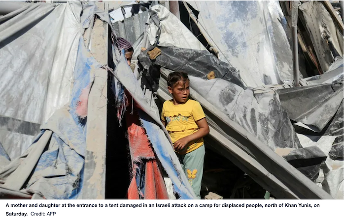
Photos: Published by HaaretzA mother and daughter at the entrance to a tent damaged in an Israeli attack on a camp for displaced people, north of Khan Yunis, on Saturday. Credit: AFP
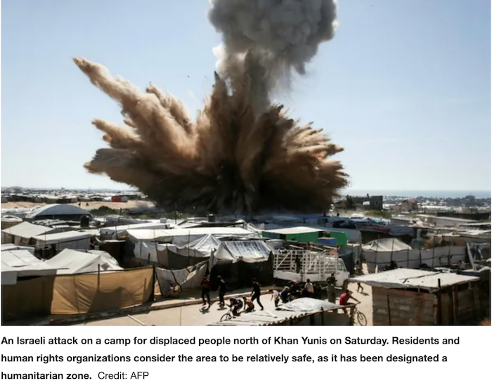
An Israeli attack on a camp for displaced people north of Khan Yunis on Saturday. Residents and human rights organizations consider the area to be relatively safe, as it has been designated a humanitarian zone. Credit: AFP
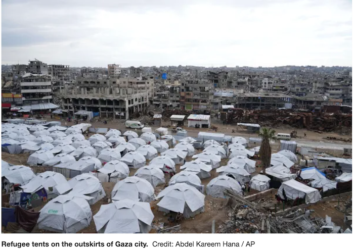
Refugee tents on the outskirts of Gaza city. Credit: Abdel Kareem Hana / AP
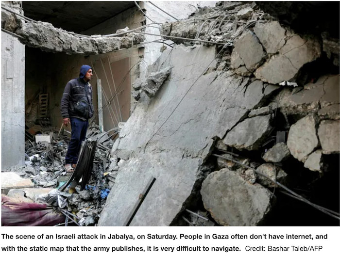
The scene of an Israeli attack in Jabalya, on Saturday. People in Gaza often don't have internet, and with the static map that the army publishes, it is very difficult to navigate. Credit: Bashar Taleb/AFP
IDF Warning. Screenshot.
____
Since January, the IDF has stopped marking safe areas on maps and has struck a zone once considered safe more than 20 times in the past month. It continues to issue open-ended evacuation orders that render most of the Gaza Strip off-limits
Nir Hasson
Apr 21, 2025
Since resuming fighting last month, the Israeli military has stopped designating humanitarian zones in Gaza and has struck the Muwasi area – previously defined as a safe zone – 23 times.
The humanitarian zone in Gaza was first delineated on May 6, 2024. It appeared on maps distributed by Avichay Adraee, the army's Arabic-language spokesman, to Gaza's civilian population from that date until the January cease-fire. While its borders shifted from time to time, the zone itself remained in place – a 62-square-kilometer area comprising 16 percent of the Gaza Strip.
The area, a sandy open space by the sea, is mainly used for agriculture and is located in Gaza's southwest. Throughout the war, Adraee and other IDF spokespeople repeatedly called on Gazans to evacuate to the area "for their safety." IDF marked off the area in yellow.
The last time the army released a map showing the humanitarian zone was on January 12. On January 15, four days before the cease-fire between Israel and Hamas was due to go into force, the army printed a map with evacuation orders and no longer included a humanitarian zone. The maps have stayed the same since the IDF started issuing them again after it ended the cease-fire.
During the cease-fire, hundreds of thousands of Palestinians left the humanitarian zone for their homes in North Gaza. However, as the fighting expanded, especially in the Rafah area, tens of thousands of displaced people returned to Muwasi, filling the area again with tents. Residents and humanitarian organizations say they consider this area relatively safe, since it was previously designated as a humanitarian zone and has almost no buildings or infrastructure.
Despite this, the UN says the area has been subject to 23 Israeli attacks. According to Palestinian officials, most of the dead in these attacks have been women and children. Last Wednesday, according to the Palestinian Civil Defense organization, 37 Gazans were killed after an attack caused a fire to spread across tents in Muwasi.
Since the resumption of fighting, the IDF has issued more than 20 evacuation orders from various parts of the Gaza Strip. Humanitarian sources indicate that the orders have no expiration date, and it is unclear whether people will be allowed to return to areas designated for evacuation after the fighting.
A recent UN report estimated that 69 percent of Gaza's land is designated as no-go zones, restricting Palestinian traffic either due to buffer zone designations or evacuation orders.
Prof. Yaakov Garb of Ben-Gurion University examined the disappearance of the humanitarian zone in response to questions raised by a group of professionals and humanitarian organizations working in Gaza.
An expert in environmental and landscape change, Garb has been assisting a group of organizations and individuals in Gaza since the start of the war by converting the IDF's maps into open files that can be downloaded and used in mapping and navigation applications. He publishes the maps and their analysis on a Harvard University website.
He says that the maps published by the IDF are difficult for the civilian population in the Gaza Strip to use effectively, undermining their intended purpose of protecting civilians from attacks.
"There is a whole doctrine regarding mapping in emergencies – people need to act quickly and need a map that they can navigate with," he notes.
"First of all, there is an orientation problem, so you can use the maps on Twitter. So they rotate them so that north isn't up. There were times when the orders were to flee south, but on the map it went to the left, westward," he says.
"Second, they blocked the option to zoom in on the map all the way. If someone is looking for a house or an escape route, it's difficult to know whether it's inside the prohibited area or not. Third, the IDF uses OSM (OpenStreetMap, a free mapping site), and there is no option for a Google background map or one with satellite imagery.
"The roads are less detailed, and this is difficult. Fourth, there are internal contradictions – areas that are both designated as an evacuation zone and in a place declared safe, for example.
"On the most basic level, people in Gaza, for the most part, don't have internet, especially when an attack is underway. So, they use a static map that the army publishes, which is hard to navigate. If you really want to caution people, do the work properly. We know that the army doesn't lack technology. When they want to create a 3-D simulation of tunnels under Shifa, they know how to do it."
The IDF declined to comment.
____
via Twitter (X)
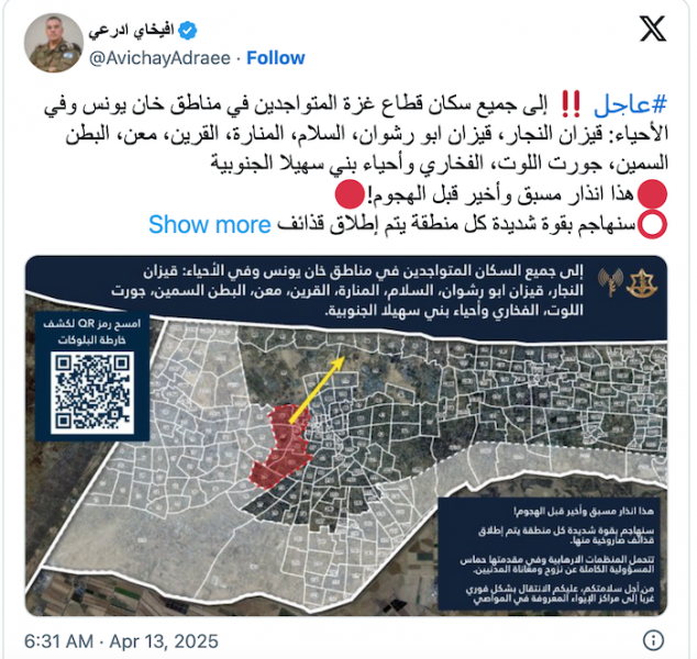
افيخاي ادرعي
@AvichayAdraee
عاجل إلى جميع سكان قطاع غزة المتواجدين في مناطق خان يونس وفي الأحياء: قيزان النجار، قيزان ابو رشوان، السلام، المنارة، القرين، معن، البطن السمين، جورت اللوت، الفخاري وأحياء بني سهيلا الجنوبية
هذا انذار مسبق وأخير قبل الهجوم!
سنهاجم بقوة شديدة كل منطقة يتم إطلاق قذائف صاروخية منها.
تتحمل المنظمات الارهابية وفي مقدمتها حماس المسؤولية الكاملة عن نزوح ومعاناة المدنيين.
من أجل سلامتكم، عليكم الانتقال بشكل فوري غرباً إلى مراكز الإيواء المعروفة في المواصي
Translated from Arabic by
#عاجل To all residents of the Gaza Strip who are present in the areas of Khan Yunis and in the neighborhoods: Qizan al-Najjar, Qizan Abu Rashwan, al-Salam, al-Manara, al-Qurain, Maan, al-Batn al-Sameen, Jurt al-Lot, al-Fakhari and the southern neighborhoods of Bani Suhaila
This is a final advance warning before the attack!
We will attack with great force every area from which rockets are launched.
Terrorist organizations, primarily Hamas, bear full responsibility for the displacement and suffering of civilians.
For your safety, you must move immediately west to the known shelters in Al Mawasi.
News Source Link
https://www.haaretz.com/israel-news/2025-04-21/ty-article/.premium/israeli-army-no-longer-designates-humanitarian-zones-in-gaza-since-fighting-resumed/00000196-5766-d9fc-adbf-5f6f355b0000https://x.com/AvichayAdraee/status/1911411983066210553
| Credibility: |  |
 |
0 |
Additional Reports
Army Opens Fire At Shepherds Herding Livestock In Gaza; 30 Sheep Killed
12:00 Sep 02, 2012
Juhr Ad-Deek (exact coordinates unknown at this time), 0.26 Kms
Here’s what happens if Israel’s AI system selects you for assassination.
12:00 Nov 11, 2024
Gaza (قطاع غزة), 0.26 Kms
WAFA: “After 15 years of blockade, four out of five children in Gaza say they are living with depression, grief and fear”
12:00 Jun 15, 2022
Gaza (غزة), 0.37 Kms
14 Palestinians Killed, 55 Injured in Gaza, in Tuesday Pre-dawn Attacks by Israeli Forces
11:00 Jul 22, 2014
Gaza (multiple locations), 0.37 Kms

Leave a Comment