Palestine Crisis Map
Sept 17, 2015: Israel OK's sniper fire against stones. 2015-2020: ~100,000 more Israeli settlers move to West Bank & Jerusalem. Jan 2022-Sept 2023: ~404 Palestinians, 58 Israelis killed. 10/7/23 to date: ~73,200+ Palestinians, ~1,850 Israelis killedVerified
Flattened Buildings, Widespread Destruction: This Is What Israel's 'Limited Operation' in Rafah Looks Like
12:00 May 23 2024 Rafa border crossing (معبر رفح) and Philadelphi Corridor (محور صلاح الدين))
Entry/Reentry Denied Property, Infrastructure, Services, Taxes: Disrupted, seized or destroyed IDF, PA, or Hamas uses lethal force against civilians Military Assault on Confined Civilian Population Collective Punishment Summary Reports

Description
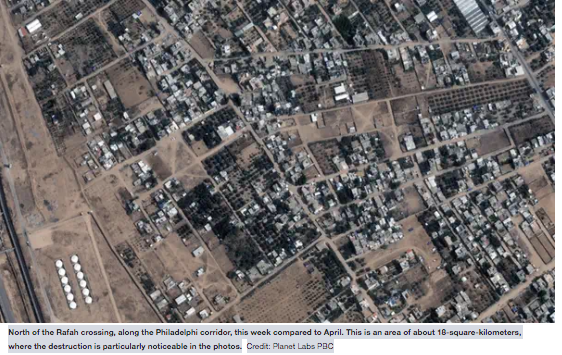
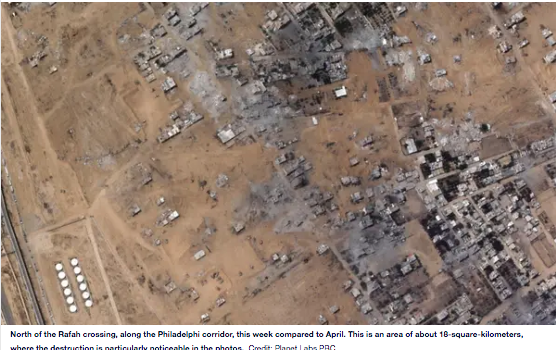
Photos: Published by HaaretzNorth of the Rafah crossing, along the Philadelphi corridor, this week compared to April. This is an area of about 18-square-kilometers, where the destruction is particularly noticeable in the photos. Credit: Planet Labs PBC
____
Satellite images show that after the seizure of the Rafah crossing, the IDF advanced northward along the Philadelphi corridor toward Rafah's city center
by Yarden Michaeli and Avi Scharf for Haaretz
May 22, 2024
Recent satellite images reveal extensive damage to the Rafah governorate in southern Gaza caused by the Israel Defense Forces' ground incursion into the area.
Although the ground incursion has been described as "limited", in practice, it is a deep ground operation, with a pattern of destruction similar to what has been seen in other cities across the Gaza Strip during earlier stages of the war.
The most recent satellite images were taken on May 19 by the private satellite company Planet Labs, and show that the IDF has flattened numerous buildings between the Kerem Shalom border crossing and the Rafah border crossing, and far beyond.
This type of satellite imagery is critical for monitoring the war's progression, since the army places tight restrictions on journalists' entry into Gaza.
Just recently, the Israeli government voted to shut down Al Jazeera – which has correspondents inside Gaza – from operating in Israel. On Tuesday, Communications Minister Shlomo Karhi confiscated equipment and shut down a broadcast set up on the Gaza border by the Associated, and quickly backtracked the decision after receiving backlash.
The IDF's ground incursion into Rafah began on May 6, when the army ordered residents in parts of the area to quickly evacuate. Israeli forces entered through the Kerem Shalom crossing area and moved northward along the Philadelphi corridor and parallel to the Egyptian border.
The forces reached and seized control of the Rafah crossing, and continued further north. According to a report by Reuters on Wednesday, IDF forces reached the center of Rafah.
Haaretz examined the satellite images, which show near-total destruction in wide areas, and major damage caused to concentrations of urban buildings. The images reveal about an 18-square-kilometer area where the destruction is prominently visible.
Between May 8 and May 20, about a thousand buildings in the Rafah governorate were either damaged or destroyed, according to U.S. researchers Jamon Van Den Hoek of the University of Oregon and Cory Scher of CUNY, who have been tracking the damage to buildings by analyzing satellite data.
According to their analysis, from the start of the war through this week, 38.5 percent of the buildings in Rafah have been damaged or destroyed.
The Rafah ground incursion has significant implications for the entry of humanitarian aid into Gaza, since the Rafah crossing is a central area where the UN and many aid organizations have been operating over the past months, and is also an important entry point for humanitarian aid.
Since the start of the incursion, the Rafah crossing has been closed, and aid organizations are warning that an extended closure could have catastrophic consequences for Gaza's population.
Since February, the Netanyahu government has insisted that a Rafah incursion is crucial for dismantling the remaining Hamas battalions and tunnels that cross into Egypt, as part of its stated goal of destroying Hamas' civil and military control of the enclave.
The international community, the UN, and aid organizations strongly oppose this move, warning that it would cost the lives of many innocent Palestinians.
According to UN estimates, between May 6 and May 18, more than 800,000 people have fled Rafah. Many have already been uprooted several times during the war, setting out with hardly any belongings, and many of them still injured.
These displaced Gazans headed north to Khan Yunis and Dir al-Balah, where tent cities were recently erected. The UN says that some are also trying to find shelter on farmland, on roads and in buildings that were damaged in the war.
In the first months of the war, the army ordered Gazans to evacuate southward and said that anyone who remained in the evacuation zone was risking their lives.
A majority of the Gaza population, an estimated 1.4 million people, crowded into the Rafah governorate, which prior to the war was home to about 300,000 people. Huge tent cities were erected there and the population has been living in difficult humanitarian conditions.
According to UN monitoring, from early February until the start of the ground invasion, the IDF bombed areas in Rafah dozens of times. The UN reported that hundreds of Palestinians have been killed in the bombings, which the IDF said were targeted against Hamas.
Parallel to the beginning of the ground incursion into Rafah, satellite images showed the tent cities there have rapidly emptied.
| Credibility: |  |
 |
0 |
Additional Reports
UN Reports Demolitions increase for 3rd consecutive month
08:02 Apr 06, 2011
West Bank (including East Jerusalem), 0 Kms
Israel's Policy in the Jordan Valley & Northern Dead Sea: Btselem, May, 2011
08:10 May 01, 2011
West Bank:Jordan Valley, Northern Dead Sea, 0 Kms
Poll: Most Israelis don’t know Jordan Valley is occupied
08:11 Jun 14, 2011
West Bank, Jordan Valley, 0 Kms

Leave a Comment